News Story
Designing an Innovative Drone System for Disaster Recovery
Published September 20, 2023

It’s estimated that natural disasters cause an average of 45,000 deaths each year globally. High-impact events like earthquakes and tsunamis have the capacity to push that number even higher.
Some of these fatalities occur when people—either swept away by raging waters or trapped under collapsed structures—are not located in time by emergency workers able to administer critical, lifesaving treatment.
To improve current disaster recovery technologies that can ultimately save more lives, a team of University of Maryland researchers is developing an innovative drone system that can help first responders and others locate people in need of immediate medical care after a natural disaster.
The UMD team—Assistant Professor of Computer Science Nirupam Roy (above left) and senior computer science major Neil Sorkin (below right)—are focusing their work on the radiofrequency (RF) waves beamed out by mobile telecommunication devices like smartphones.
“Imagine that a building has collapsed, and people are trapped inside. There are piles of debris blocking their way out, but the debris is not blocking the radiofrequency waves emitting from their phones,” says Roy, who has a joint appointment in the University of Maryland Institute for Advanced Computer Studies and is a core faculty member in the Maryland Cybersecurity Center.
Potentially both low-cost and resource-efficient, the system developed by Roy and Sorkin can quickly detect RF waves from smartphones, relaying that information back to emergency responders.
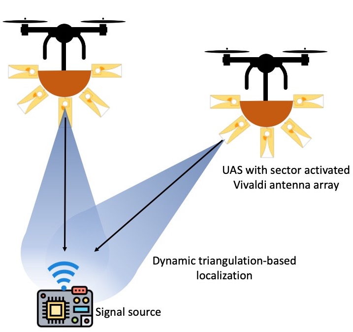
“We can do this with any RF source, including wireless networks and walkie-talkies,” Sorkin explains. “It just takes at least two small drones placed in different locations and bearing lines, or the angles between the primary compass directions. Each drone will point in the direction of the RF source from its respective location. Using our system, we can calculate the intersection of these two directions and that’s where the RF-emitting device should be.”
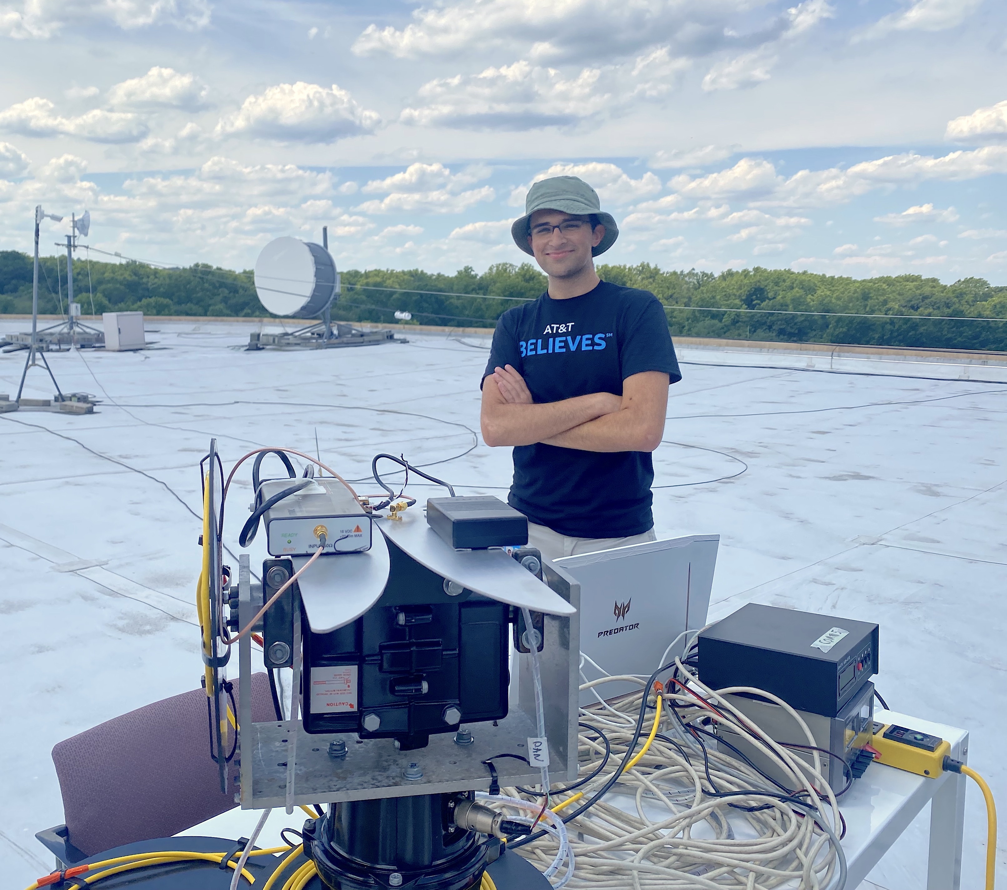
The idea for their project began in Summer 2022 when Sorkin was interning at AT&T, working on a cellular signal-finding robot that helps boost mobile hotspots in remote or rural areas where cell signals are often weaker than in urban hubs.
“The robot finds the best direction to point an antenna toward in order to maximize signal strength,” he says. “As I was working on it, I realized that there were many other problems that this type of technology could potentially solve.”
Sorkin brought his ideas to Roy, whose research in the iCoSMoS Lab at UMD aligned with Sorkin’s goals in terms of radio frequency research.
With Roy’s guidance and experience developing SIRIUS (a low-power sensor network capable of communicating directional codes to any received signal), the duo sketched out a drone system capable of quickly scanning potentially hazardous environments for cell phone signals.
They dubbed their creation ‘RF Trooper,’ a reference to the troopers in the Star Wars franchise. But they still needed to resolve some challenges.
“It’s an onion-peeling problem because the devil lies in the details—how can a tiny drone hold onto a big battery pack? How can it travel an appropriate distance while on limited power? There were various practical limitations that we had to consider,” Roy says. “Size, weight, power and even financial costs in developing these kinds of systems are problems that any engineer or scientist will encounter.”
Sorkin added that each device would have taken tens of thousands of dollars to produce, making it insanely difficult to scale up. “We had to ask ourselves if it was possible to develop sensing mechanisms that are super lightweight, use only a few milliwatts of power but still capable of identifying signal source locations,” he says.
The solution that Sorkin and Roy eventually arrived at was simple: stitching together multiple perspectives taken from the deployed drones, instead of relying on drones constantly scanning in synchrony to find the direction of a cell signal.
They decided to equip their drones with special directional antennae capable of covering a wide range of RF frequencies, including the frequencies that 4G and 5G cell phones operate on. Much like how a person can hear a sound in their left or right ear and tell which way the sound came from, drones with these antennae were able to decipher the general direction of signal sources.
Through this technique, the system could learn both its own location with reference to the drones and find the location of other signal sources at a much lower energy cost—therefore eliminating the need for a bigger battery, a stronger or larger drone and the associated financial expenses.
With many of the technical challenges now resolved, Roy and Sorkin have applied for funding from various organizations, including the U.S. Army and the National Science Foundation, to fully produce the drone system and put it into operation.
“RF Trooper is a futuristic goal that’s meant to bridge lab research to real life,” Roy says. “We’re translating these concepts and deploying them to benefit regular people, not just researchers.”
The UMD team believes their project has applications beyond disaster recovery efforts and could also help people in urban areas that may be lost or trapped in an unfamiliar place due to dementia or Alzheimer’s.
Sorkin is already developing similar projects for his new startup, Redhelm Labs, which he founded at Startup Shell, a UMD student startup incubator. Looking ahead, he hopes to create products that will solve the drone industry’s problems with efficiency, safety and sustainability.
“My overall goal is to really make a difference in the world with my engineering skills,” Sorkin said. “Thanks to Professor Roy and Startup Shell, I feel that I’m getting the support and resources I need to do just that.”
—This article is adapted from a news release from the College of Computer, Mathematical, and Natural Sciences.
Related Stories
Stories / July 11, 2022
UMD Team Wins Award for Designing a Navigation Sensor for Mini...

Stories / July 14, 2021
UMD Team Receives Best Demo Award for Mobile Sound Localization...

Stories / November 18, 2020
UMIACS Faculty Researcher Asks: Could Your Robotic Vacuum Be...

Stories / October 30, 2019
Roy Receives 2019 CSL Thesis Award
Stories / January 29, 2024
Fighting Deepfakes, Shallowfakes and Media Manipulation

Stories / May 22, 2023
MC2 Researchers Present Nine Papers at IEEE Symposium on...

Stories / November 18, 2022
UMIACS Faculty Receive Meta Research Awards to Advance AI

Stories / March 28, 2022
World Traveling Postdoc Finds a Home at MC2

Stories / July 26, 2021
New Postdocs Bring Expertise in Secure Software Development and...
Stories / February 24, 2021
Maryland Cybersecurity Center Kicks Off Second Year of...